

March 22, 2025
October 10, 2026
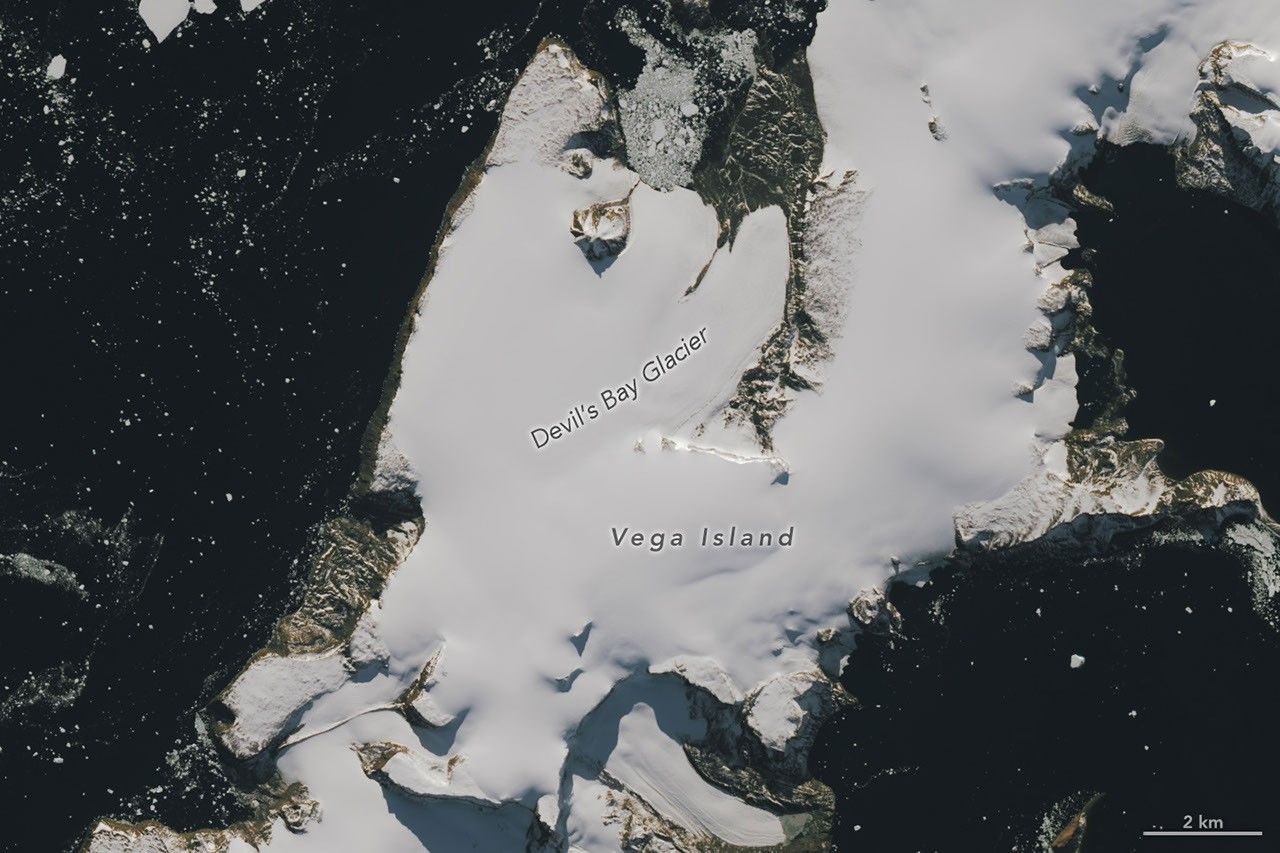
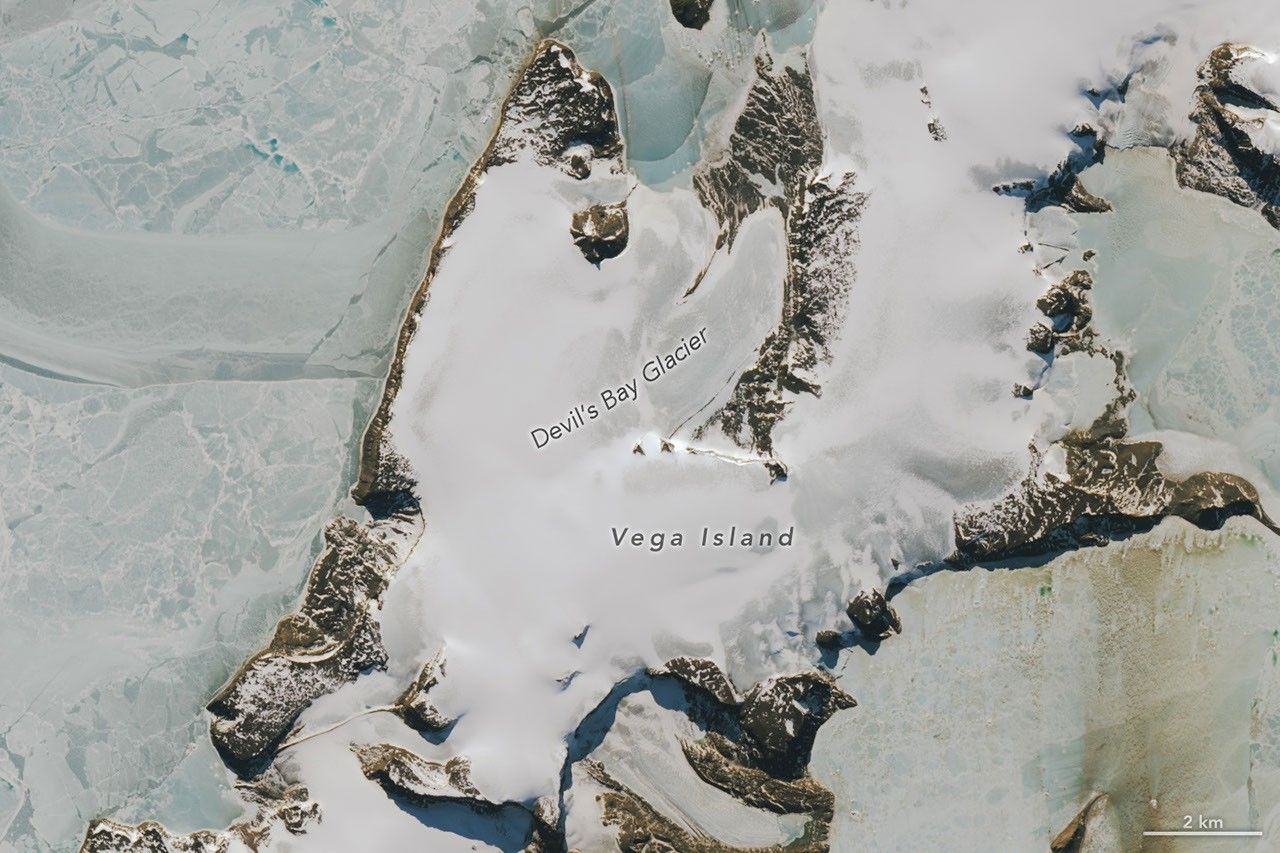
Shrouded in ice in the lonely Weddell Sea, Vega Island is an eerie sight to behold. On this speck of land east of the Antarctic Peninsula, ice, rock outcrops, and glacial moraines combine to create the appearance of a smirking skull in profile looking toward Devil Island.
These images show Vega Island’s creepy countenance at the start of austral autumn (left) and in spring (right). They were acquired with the OLI (Operational Land Imager) on Landsat 9 on March 22, 2025, and October 10, 2026, respectively. (Clouds obscured the island in March 2026.) A nunatak jutting out of the ice has the appearance of an eye socket, a lateral moraine forms a mouth, and Bahía del Diablo (Devil’s Bay) Glacier constitutes a jawbone. In the March 2025 image, a layer of snow coats the ice, which is typical of the region’s wettest month. That contrasts with the October 2026 image, when snow is absent from large areas and darker ice surfaces are visible.
Above-average temperatures in winter 2026—particularly in June—were partly responsible for so much bare ice in October, said glaciologist Mauri Pelto of Nichols College. The ice exposed on Vega and nearby islands indicates limited new snow accumulation over the winter, further reduced by sublimation and wind scouring, he said. “The winter season was no treat for these glaciers.”
The melt season ahead may also be more trick than treat. Bare ice is darker than snow and absorbs more solar energy, meaning that melting is poised to speed up as the days grow longer and warmer. “Even a thin cover of new snow from a spring storm would be helpful in the short run,” Pelto said. “When entombed in snow and ice, the skull is preserved. But when exposed to melt, it weathers away, which will lead to a changing jawline and expanding eye socket.”
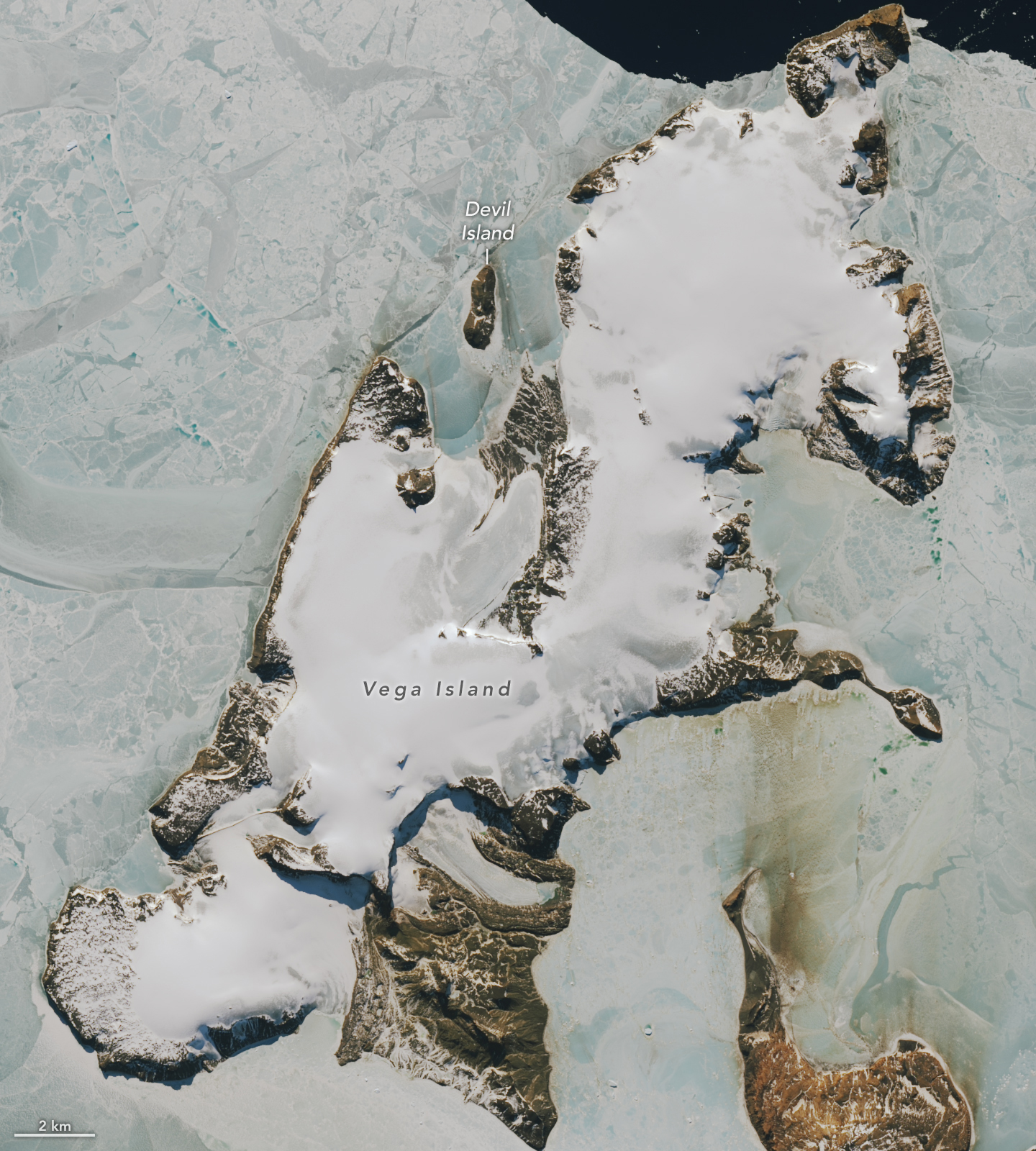
The first comprehensive mapping of Vega Island’s ice was aided by Landsat imagery. In a study published in 1982, scientists described the island’s four ice caps with protruding rocky cliffs and outlet glaciers. They leveraged early Landsat observations along with aerial photos and topographic maps to catalog 29 glaciers on Vega.
Of those glaciers, Devil’s Bay Glacier has been closely monitored since the austral summer of 1998-1999, with researchers measuring an overall decline in its mass. Satellite images acquired in recent decades show ice loss from other glaciers on the island as well, with increased areas of exposed bedrock.
Long before scientists began tracking its glaciers, Vega was a bright spot in a tale of terror born out of early exploration of the area. The Swedish Antarctic Expedition of 1901-1903 set out to study the geography, geology, climate, and wildlife on and around the eastern Antarctic Peninsula. The party became split into three groups during their explorations, isolated for a winter in different locations. Adding to the horror, they lost their ship to the pack ice. Cape Well-met, as it would come to be known, off the “forehead” of the Vega Island skull, was the site of a happy reunion of two of the groups in spring 1903. Soon thereafter, an Argentinean expedition rescued the survivors of the ordeal.
NASA Earth Observatory images by Lauren Dauphin, using Landsat data from the U.S. Geological Survey. Story by Lindsey Doermann.


References & Resources
- From a Glaciers Perspective (2026, October 24) Snow Free Glacier Surfaces on Antarctic Peninsula October 2026. Accessed October 28, 2026.
- From a Glaciers Perspective (2012, January 22) Northwest Vega Island, Antarctica Glacier Retreat. Accessed October 28, 2026.
- Rabassa, J., et al. (1982) Glacier Inventory of James Ross and Vega Islands, Antarctic Peninsula. Annals of Glaciology, 3, 260–264.
- Skvarca, P., et al. (2004) Mass balance of ‘Glaciar Bahía del Diablo’, Vega Island, Antarctic Peninsula. Annals of Glaciology, 39, 209–213.
- South-Pole, Otto Nordenskjöld. Accessed October 28, 2026.
- Swoop Antarctica (2024, October 8) The greatest Antarctic survival story you’ve never heard of. Accessed October 28, 2026.
- World Glacier Monitoring Service (2025) Glaciar Bahía del Diablo. Accessed October 28, 2026.
You may also be interested in:
Stay up-to-date with the latest content from NASA as we explore the universe and discover more about our home planet.
In summer 2026, a substantial iceberg calved from Petermann Glacier in northwest Greenland and swiftly drifted into Nares Strait, colliding…
The expanse of glacial ice on Canada’s Baffin Island lost its snow cover quickly and early in summer 2026, revealing…

One narrowing icefall remains the linchpin for the Alpine glacier—and it may not be long for this world.