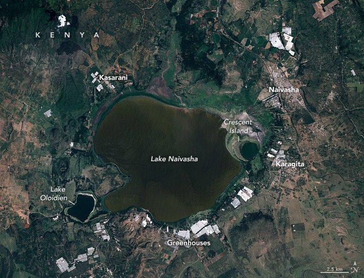


January 30, 2010
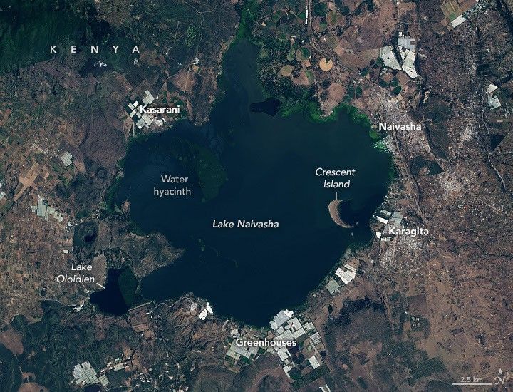
January 26, 2026
Kenya’s Lake Naivasha has long been a place of change and reinvention.
In precolonial times, the nomadic Maasai people used the lake and surrounding grasslands to water and raise cattle during the dry season. The Maasai were eventually displaced by British colonists in the late 19th and early 20th centuries, including a group of free-thinking aristocrats who arrived in large numbers in the 1920s through 1940s. Known as the Happy Valley set, these newcomers cultivated lavish estates and were notorious for reveling in a culture of excess. Their influence faded in the 1950s and 1960s amid scandal and the overthrow of colonial rule, allowing the area to transform into a center of wildlife tourism, flower farming, and geothermal energy production.
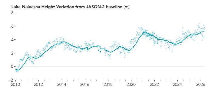
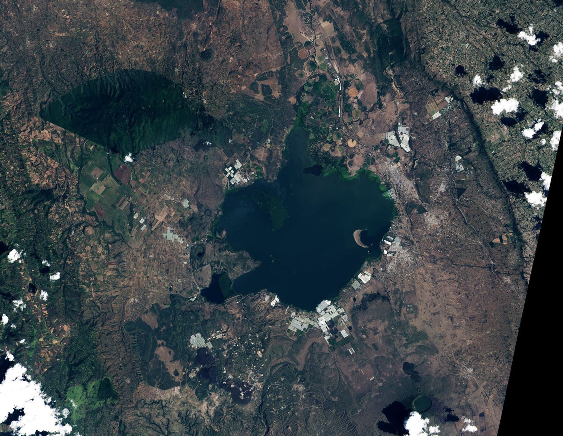
Now the lake faces another major change: rapidly fluctuating water levels. The name Naivasha comes from a Maasai word meaning “that which heaves,” an apt description of the freshwater lake over the past 25 years. Satellite altimetry measurements of the lake’s depth indicate an increase of about 7 meters (23 feet) since 2010, roughly the height of a two-story building. Over the same period, Landsat observed a roughly 40 percent increase in the lake’s area, adding 50 square kilometers (19 square miles) of water, equivalent to roughly 15 Central Parks.
The human and economic toll of the rising water levels is considerable, said Mathew Herrnegger, a hydrologist at BOKU University in Vienna, Austria. Homes, flower farms, and roads along the shores have all flooded in recent years, displacing large numbers of people. Lake Oloidien, once a separate lake, has effectively merged with Naivasha, bringing an influx of saline, alkaline water to Naivasha’s freshwater system.
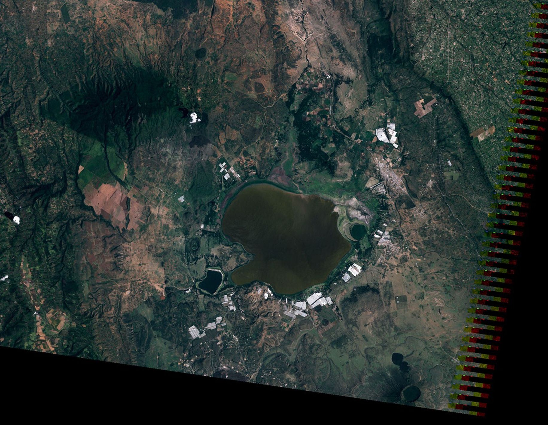
The Landsat images above compare the same area in January 2010 (left) and January 2026 (right), illustrating the scope of the changes. Neighborhoods in the southwestern part of the town of Naivasha have been particularly hard hit. Flooding has been widespread in the neighborhood of Kihoto, with entire town blocks inundated, including police stations, churches, hotels, restaurants, electrical power substations, and sewer systems.
“Increased rainfall is the primary driver,” Herrnegger said. Mean annual rainfall rose by about 30 percent between 2010 and 2020 compared to the preceding decade, with a 318 percent increase in high-intensity rainfall, he said. Because the lake lies in a closed basin and has no surface outflow, it is especially sensitive to even modest changes in the water balance. Herrnegger and colleagues estimate that a 0.4–2.0 percent increase in annual rainfall is sufficient to explain the dramatic rises. “It is a system that, once tipped, responds strongly,” he said.
The flower industry around the lake, which produces hundreds of millions of dollars in exports per year, is losing greenhouses, farmland, packing sheds, and worker housing on a significant scale. In communities such as Sulmac Village, Karagita, and Kasarani, many greenhouses that just a decade ago were set back a kilometer or more from the water now have lakeshore views.
Crescent Island—once a peninsula along the lake’s southern shore near several former Happy Valley estates and country clubs—is now primarily a game sanctuary and wildlife tourism destination. Hundreds of hippos live in the lake, and people, especially commercial fishermen, are encountering them with more frequency as waters rise.
The images also show the expansion of aquatic vegetation, especially water hyacinth. Remote sensing scientists and journalists have documented a rapid proliferation of the plant over the past two decades, which has interfered with fishing and tourism and possibly contributed to the lake’s rising water levels by slowing evaporation.
Other researchers have pointed to tectonic influences changing the rate of groundwater recharge into the lake as a possible contributing factor. In addition, the accumulation of sediment may be filling shallow areas and reshaping the lake floor such that water levels may be rising and increasing the lake extent even though the volume of water held by the lake may be unchanged, explained Jamie Shutler, a professor of earth and environmental science at the University of Exeter in England.
“Given the large number of people who rely on this lake for food and their livelihoods, the change we’re seeing from the satellite imagery combined with the stories of displacement is alarming,” Shutler said. “We need more research to assess exactly how much the volume of water is changing each year and why.”
NASA Earth Observatory images by Lauren Dauphin, using Landsat data from the U.S. Geological Survey and water level data from Global Water Measurements. Story by Adam Voiland.
References & Resources
- Africa is a Country (2026) The human cost of Kenya’s expanding lakes. Accessed June 18, 2026.
- Aguta, P., et al. (2018) An Assessment of the Role of Water Hyacinth in the Water Level Changes of Lake Naivasha Using GIS and Remote Sensing. American Journal of Remote Sensing, 6(2), 74-88.
- Al Jazeera (2025, November 20) Kenyan lake flood displaces thousands, ruins homes and schools. Accessed June 18, 2026.
- AP News (2025, December 22) Scientists and data explain why Kenya’s lakes are rising as thousands face an uncertain future. Accessed June 18, 2026.
- Daily Nation (2026, January 7) Sh81bn at risk as climate crisis drowns flower farms. Accessed June 18, 2026.
- Freshwater Biological Association (2024, November 13) The sad tale of Lake Naivasha, Kenya; a mountain of underused knowledge. Accessed June 18, 2026.
- The Guardian (2022, March 17) A drowning world: Kenya’s quiet slide underwater. Accessed June 18, 2026.
- Guto, K.C., et al. (2023) Seasonal variations of water quality parameters and their effect on the phytoplankton along a salinity in the Lake Naivasha-Oloiden. Accessed June 18, 2026.
- Herrnegger, M., et al. (2021) Hydroclimatic analysis of rising water levels in the Great Rift Valley Lakes of Kenya. Journal of Hydrology: Regional Studies, 36,100857.
- NASA Earth Observatory (2020, September 7) Rising Waters on Kenya’s Great Rift Valley Lakes. Accessed June 18, 2026.
- National Geographic (2021, January 21) Human-hippo conflicts are exploding in this pristine patch of Kenya. Accessed June 18, 2026.
- Republic of Kenya (2021) Water Levels In Kenya’s Rift Valley. Accessed June 18, 2026.
- SEI (2023, May 1) Revisiting the rising Rift Valley lakes: a glimpse into Kihoto’s struggles. Accessed June 18, 2026.
- The Standard (2025, December 10) How water hyacinth has paralyzed fishing activities in Lake Naivasha. Accessed June 18, 2026.
- Utterly Interesting, The Happy Valley Set: Colonial Debauchery in Kenya’s Highlands. Accessed June 18, 2026.
- Walker, D., et al. (2022) Quantifying water storage within the north of Lake Naivasha using sonar remote sensing and Landsat satellite data. Ecohydrology & Hydrobiology, 22(1), 12-20.
You may also be interested in:
Stay up-to-date with the latest content from NASA as we explore the universe and discover more about our home planet.

Lake Unter-See in Antarctica, sealed beneath thick ice, has unusual water chemistry and cone-shaped microbial structures resembling some of Earth’s…

The glacial lake left a layer of silt and clay in southeastern Manitoba, creating fertile farmland that was divided during…

Drought and water releases drained the Arizona reservoir to levels that have led to widespread fish deaths.