
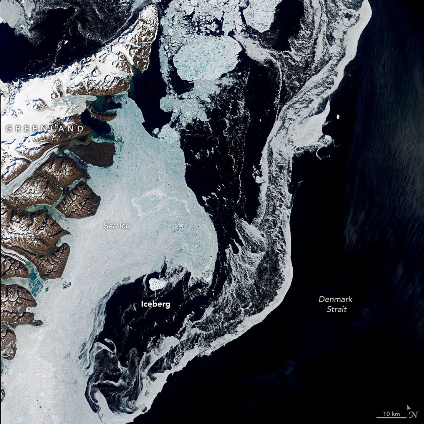
Greenland’s jagged coastline is lined with fjords, many of them cradling marine-terminating glaciers that routinely calve icebergs into the water. It’s common to see these bergs, small and large, drifting in the island’s fjords each summer once the sea ice breaks up. In summer 2026, one exceptionally large berg turned up in the Denmark Strait—more than a thousand kilometers south of where it apparently originated.
These images, captured by the OLI (Operational Land Imager) on Landsat 9, show the iceberg on June 12 as it drifted in the strait between Greenland and Iceland. It was just south of Kangikajiip Appalia, a cape on Greenland’s east coast visible in the scene’s upper left, amid a mixture of sea ice and berg fragments known as “mélange.”
Alexis Denton, oceanographer and chief scientist with the International Ice Patrol, noted that several clues indicate it is an iceberg rather than thick, multi-year sea ice: its proximity to shore, its whiter color, and larger size compared to the surrounding sea ice. Measuring roughly 17 square kilometers (7 square miles) on June 12, the iceberg was about five times the area of New York City’s Central Park. That’s modest compared to the behemoth bergs that calve from Antarctic glaciers and ice shelves but large by Greenland standards.
Keld Quistgaard, a senior ice advisor with the Danish Meteorological Institute’s Greenland Ice Service, noted that it originated in Jøkelbugten—a bay in northeastern Greenland. The berg’s precise origin within that bay, however, remains something of a mystery. It’s possible that the berg broke off from Zachariæ Isstrøm or its adjacent remnant ice shelf. The ice shelf, which together with Zachariæ Isstrøm once filled the bay, was abandoned after the glacier rapidly retreated in the early 2000s.
Tracing its path back through satellite imagery is challenging. Through spring, the bay and surrounding coastal areas are choked with sea ice and berg fragments, making individual bergs hard to distinguish, especially if covered in bright snow. In late May, for instance, the berg was surrounded by numerous look-alikes. Only later in the season, as it drifted farther south and the ice around it thinned out, did it become distinct enough to easily spot.
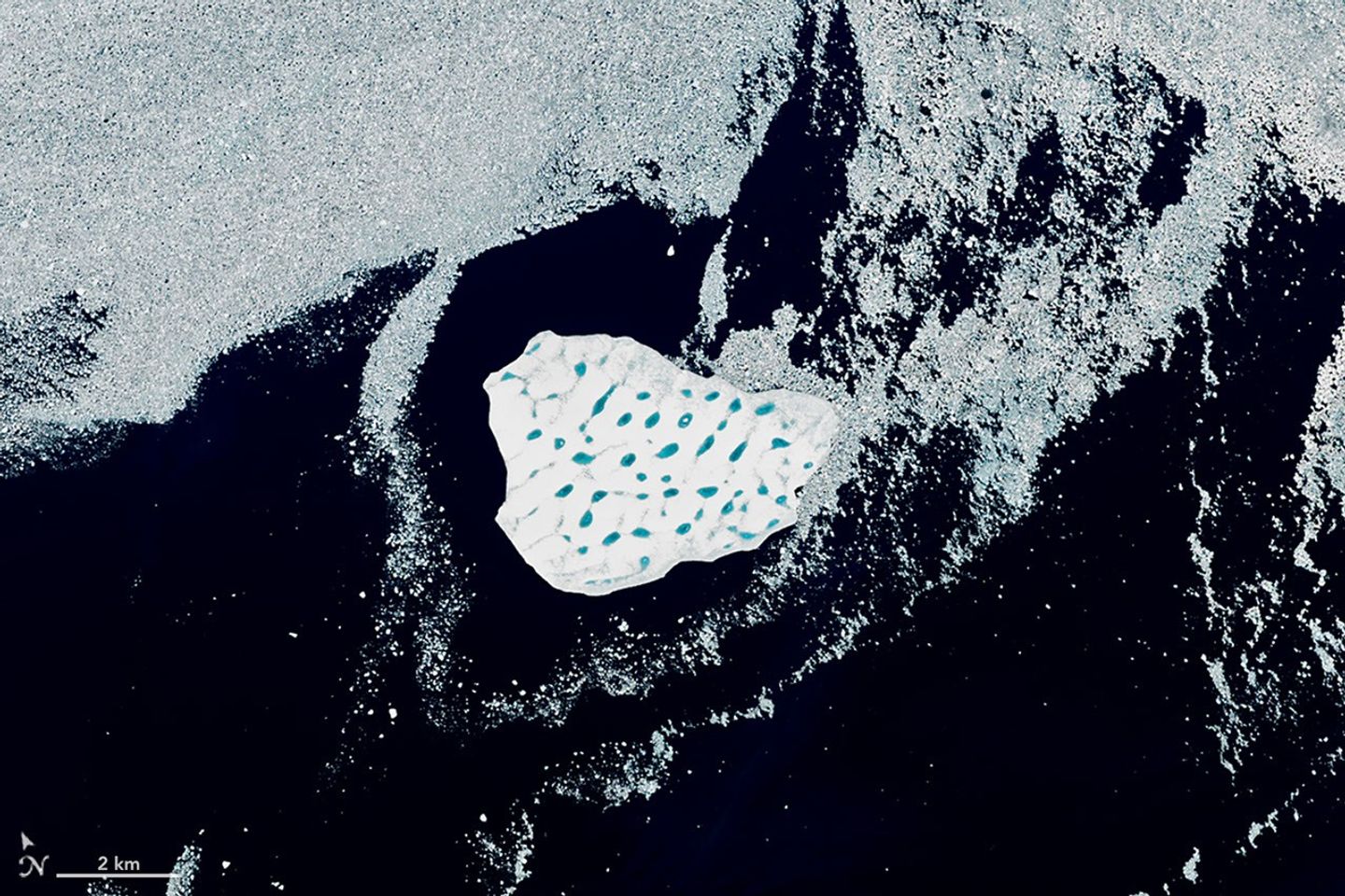
Its size and striking network of blue meltwater ponds offer some clues to its origin, according to Christopher Shuman, a retired University of Maryland glaciologist. Shuman thinks the berg broke from the remnant ice shelf rather than the glacier itself. Bergs calved from Zachariæ Isstrøm tend to be smaller, he said. Also, the berg’s surface—pocked with meltwater ponds, “like Swiss cheese”—closely resembles the remnant shelf ice. Past satellite images show pieces of that shelf ice drifting south and getting trapped among islands bordering the bay, where winds and tides have jostled them for years.
As of mid-August, the berg was about 1,500 kilometers (900 miles) from the bay, drifting south on the Greenland Coastal Current into the North Atlantic. Quistgaard expected the iceberg to gradually disintegrate throughout the month. Recent satellite imagery suggested it was doing just that.
Breaking up in the Denmark Strait means that remnants of the berg are unlikely to drift into busier shipping lanes that go past the southern tip of Greenland. “Its journey is a reminder of the dynamic Earth,” Shuman said, “as well as the seasonal variability of the ice in this part of the North Atlantic.”
NASA Earth Observatory images by Lauren Dauphin, using Landsat data from the U.S. Geological Survey. Story by Kathryn Hansen.

References & Resources
- NASA Earth Observatory (2015, December 4) Zachariæ Isstrøm Glacier, Greenland. Accessed August 19, 2026.
- Sutherland, D. A., and Pickart, R. S. (2008). The East Greenland Coastal Current: Structure, variability, and forcing. Progress in Oceanography, 78(1), 58-77.
You may also be interested in:
Stay up-to-date with the latest content from NASA as we explore the universe and discover more about our home planet.
Scientists relied on satellite data to understand how the Antarctic glacier lost so much ice so rapidly.

The expanse of glacial ice on Canada’s Baffin Island lost its snow cover quickly and early in summer 2026, revealing…

The color of Adélie penguin droppings reveals what the birds are eating, offering scientists a way to track how sea…